


The Mallory Cave hike is an exciting trail that offers some of the most stunning views in Boulder. This one stands out as someone who has explored many trails in Colorado stands out. I first discovered it as an adult, even though I spent my kid years growing up in Boulder County, where hiking is a standard weekend activity. Unlike the more famous Mount Sanitas route, this trail takes you through the rugged landscape near NCAR, offering a challenging yet rewarding adventure. If you’re looking for a hike that truly immerses you in nature, this is the one you need to try.
When I set out on a hike, I always rely on AllTrails Plus. This app provides offline maps, which are incredibly helpful, especially on more arduous intermediate routes like this. I use the lifelines feature to keep my friends and family updated on my location, prioritizing safety. The membership is well worth the cost, especially with a discount that brings it down to just $25 a year—less than $2 a month! Whether you’re an experienced hiker or just starting, having the right tools can make a big difference.
Hiking this trail was an unforgettable experience—the views at the top completely blew me away. The rugged rocks and scenic landscapes make it the perfect spot to snap a reel for Instagram and share the beauty with others. If you love capturing the essence of nature, this hike won’t disappoint. I always check the rating of a trail before heading out, and this one met my expectations. The adventure inspired me to read about more hikes and plan my next outdoor escape. There’s always something new to explore in the breathtaking wilderness of Colorado.
Boulder’s Hidden Trail with a Fascinating Past
The story of Mallory Cave begins in 1932 when a CU Boulder student, E.C., learned about a mysterious spot hidden deep in the Dinosaur Mountain area. Some loggers working nearby had mentioned a cave, but its exact location was unknown. Driven by curiosity, he set out on his own discovery mission and finally found it. Instead of sharing it right away, he kept it a secret for several years. Today, the trail to the cave starts near NCAR (National Center for Atmospheric Research) and winds through stunning landscapes filled with towering trees and rocky cliffs. The experience of reaching this cave, once hidden from the world, makes the journey even more exciting.

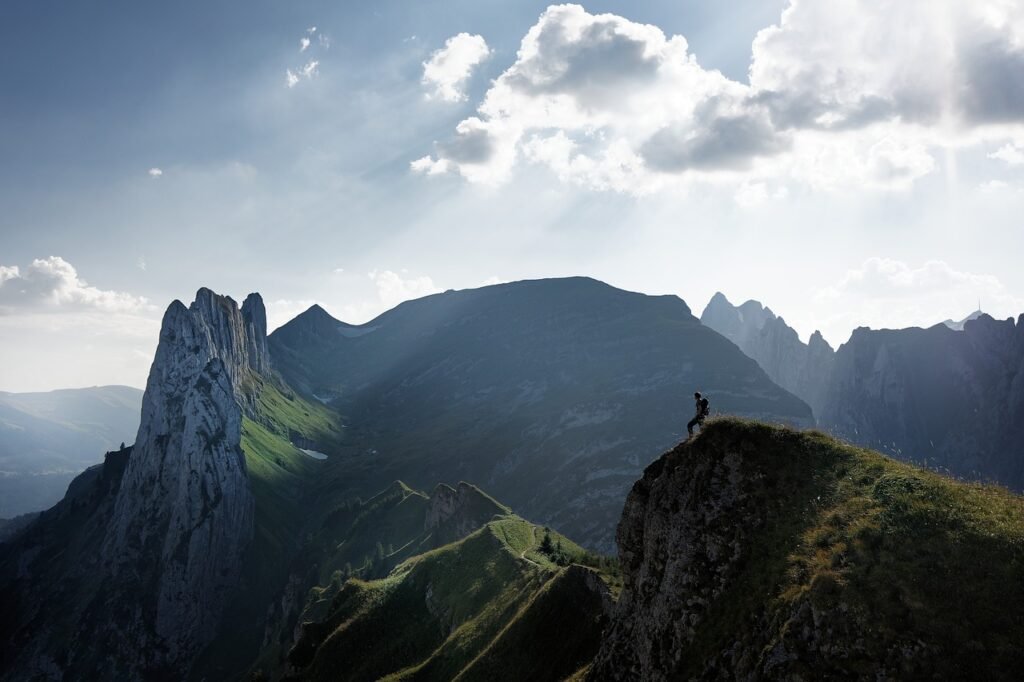
I started my hike with no expectations, but as I climbed higher, I quickly fell in love with the breathtaking scenery. The top offers an incredible view of the Flatirons, mountains, and the city of Boulder below. Standing at the edge of Der Zerkle Crag, I could see the distance stretching beyond NCAR’s pink building, a sight that felt truly special. Every step along the way made me feel like I was being treated to nature’s best. If you ever visit, I highly recommend this adventure—it’s well worth the effort. And if I had to rate it, my score for this trail would easily be 9/10.
Finding the Trail to Mallory Cave
The Mallory Cave hike is one of the most exciting hiking experiences in Boulder, CO. Nestled on Dinosaur Mountain; this trail can be easily reached from the NCAR parking lot. The iconic pink building atop the hill serves as a landmark visible from many places in the city. To get there, follow the driving directions by taking Table Mesa Drive all the way west until the end. Once you arrive, use the map to navigate the scenic route to the cave.
Elevation Challenge on the Trail
The Mallory Cave Hiking Trail is a thrilling climb with an elevation gain of 1174′ from the parking area to the peak. Reaching the highest point at 7076′, this trail tests endurance while rewarding hikers with breathtaking scenery. Every step brings a sense of achievement as you ascend toward the iconic Mallory Cave, making it a true adventure highlight.
Finding the Trailhead
The Mallory Cave hike begins at the official trailhead near NCAR, making it easy to follow the signs along the trail. After you park in the NCAR parking lot, walk for a few minutes until you cross the Mesa Trail junction. As you pass landmarks, you’ll spot a water tank, which means you’re close to the starting point. If you check a photo of the route beforehand, it will help guide your way.
Easy Parking for Your Hike
The best place to park for the hike is at NCAR (National Center for Atmospheric Research), where you’ll find plenty of spaces in the parking lot. It’s simple to reach. Just take Table Mesa Drive west, continue up the hill, and follow the road until it dead-ends at the NCAR facility. This parking area offers a convenient and stress-free start to your adventure.
Taking the Bus to the Trailhead
No public transport goes directly to the NCAR parking lot, but you can take the 204 bus to get close. This bus runs through the Martin Acres neighborhood in South Boulder, passing along Broadway before making a U-turn at Ithaca Drive. To get to the trail, get off at the Ithaca stop and prepare for a 45-minute walk uphill. While it may take some time, the route offers beautiful scenery.
For those looking for the fastest route, follow the Table Mesa Trail until you reach the junction with the Bear Trail. It’s only about 15 minutes from there before you reach the NCAR parking lot. This shortcut saves time and gets you to the start of the hike quicker, making it a great option if you’re eager to explore Mallory Cave.

Beginning Your Hike
Start your Mallory Cave hike at the NCAR parking lot, where the trailhead is easy to find. From there, follow the signs along the trail, leading you toward the scenic route up to the cave. This well-marked path ensures you stay on track as you enjoy the adventure.
The Experience of Hiking to Mallory Cave
Beginning the Hike at NCAR
The start of the hike is peaceful and calm, making it a great way to ease into the adventure. As you leave the NCAR parking lot, you’ll spot a map on the right, which I highly suggest taking a photo of before heading out. A large rock on the left marks the beginning of the trail, engraved with the name Walter Orr Roberts. The path is well-marked and surrounded by trees, providing a scenic introduction to one of the best hikes in the area.
After a leisurely walk for about 8 minutes, the trail stays wide and flat, offering a clear view of Bear Peak and Dinosaur Mountain in front of you. This section is easy and allows you to enjoy the fantastic scenery before the climb becomes more challenging. The Mallory Cave route is well worth the journey, with breathtaking sights ahead.
Stay on the Right Trail
As you follow the signs toward Mallory Cave, the path will lead you downhill, guiding you into a beautiful valley. Along the way, you’ll notice the Bear Trail at the bottom, which eventually climbs to Bear Peak. Stay on the marked path as it begins to curve to the right, giving you stunning views of the Flatirons in the distance to your left. Looking front, you’ll also see the road you drove on to reach the parking lot, along with tall trees and the towering mountains in the background.
The trail is well-marked but soon becomes more steep as you ascend the rocky terrain. Keep moving, and after about 10 minutes, you’ll arrive at an important landmark—the water tank. Another photo opportunity awaits, as the surroundings here are breathtaking. You’ll also pass the Walter Orr Roberts sign, marking a key point near NCAR before continuing toward the cave.
Exploring Valleys and Rocky Paths
Running into a massive water tank covered in graffiti while surrounded by nature always feels funny, but it’s part of the experience on this trail. As you continue walking, keep left and follow the path into a beautiful valley with fantastic views. After a few minutes, you’ll notice a sign that doesn’t mention Mallory Cave, where you must go left. Along the way, you’ll spot a photo opportunity with a giant green structure hidden in the forest, the famous water tank. Once you cross the Mesa Trail, you’ll find the official hike trailhead, marking the start of the real adventure.
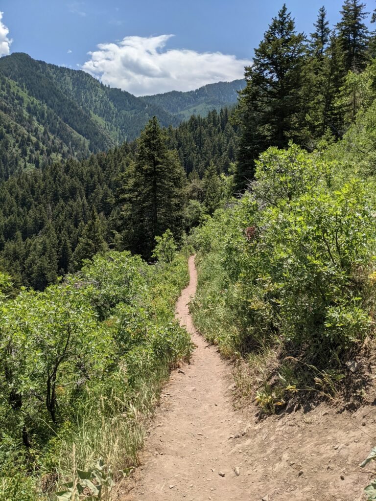
The path feels more challenging as it moves along the mountain’s edge and into a tree-covered area. The trail gets narrow and rocky, so having proper footwear is essential. The terrain becomes more brutal as you ascend, but the shade from the trees helps on a hot day. You’ll know you’re near the top when you see a flat rock face to your left. Give one final climb over the rocks to reach a wide open area where you’ll find signs about the bats that live near the cave.

Reaching the Final Stretch
As you near the end of the hike, you’ll arrive at a flat area with signs about bats, signaling that you’re close. If you visit between April 1 and October 1, you won’t be able to climb up to the cave due to a net blocking the entrance. But if you go in the fall or winter, you can approach the steep rock face, though entry is not allowed. The path becomes more rocky as you start to go up the Mallory trail’s final part; from here, you can look above to see the impressive rock formations.
For the last climb, move along the edge of the mountain to reach a beautiful lookout spot over Boulder, offering breathtaking views and perfect spots for photos. The way up is not easy, as the narrow terrain zig-zags back and forth toward Dinosaur Mountain with the Flatirons behind you. You can even climb atop some rocks for a better view, but be careful—it’s a long way down if you slip. Take precautions as you move over the rugged landscape, ensuring the adventure’s safe and rewarding finish.

Taking in the View from Above
As you look down while hiking, the views over Boulder are spectacular. Parts of the trail feel wild and untouched, making the experience feel even more special. You can see the Flatirons behind you from the top, adding to the stunning scenery. If you’re interested in Mallory Cave climbing, the Der Zerkle Crag is a good spot near the summit, offering another great place to take in the landscape.
Do Bats Live in Mallory Cave?
Yes, Townsend bats live in Mallory Cave during the summer, making it an essential habitat for these creatures. As the seasons change, they move to higher elevations in the fall and winter, leaving the cave empty until the warmer months return.
Mallory Cave Restrictions and Closures
To protect bats from white-nose syndrome, a deadly disease that can wipe out their entire population, Boulder OSMP (Boulder Open Space and Mountain Parks) enforces strict precautions. The cave entrance remains closed annually, ensuring the bats stay protected in their natural habitat. The entrance is covered with bars that allow bats to enter and exit, but humans cannot go inside.
The steep path to the cave is also blocked from April 1 to October 1 to prevent disturbances. As shown in the photo, a mesh netting blocks the entrance. From October 1 – March 31, hikers can climb up and get closer to the cave, but they can never entirely go inside. This balance allows visitors to experience the trail while respecting the wildlife that depends on it.
Duration of the Mallory Cave Hike
It took me about 1.5 hours to reach the peak from the parking lot, following the trail on an in-and-out route. On the way down, I retraced my steps, which took under one hour. I spent some time eating snacks, admiring views, and climbing rocks, making my total trip about 4 hours, though it can be finished in 3 hours for a quicker hike. The official route is 1 mile long, but it is a steep trek, with a total distance of 3 miles from the parking area.
How Difficult is the Mallory Cave Hike?
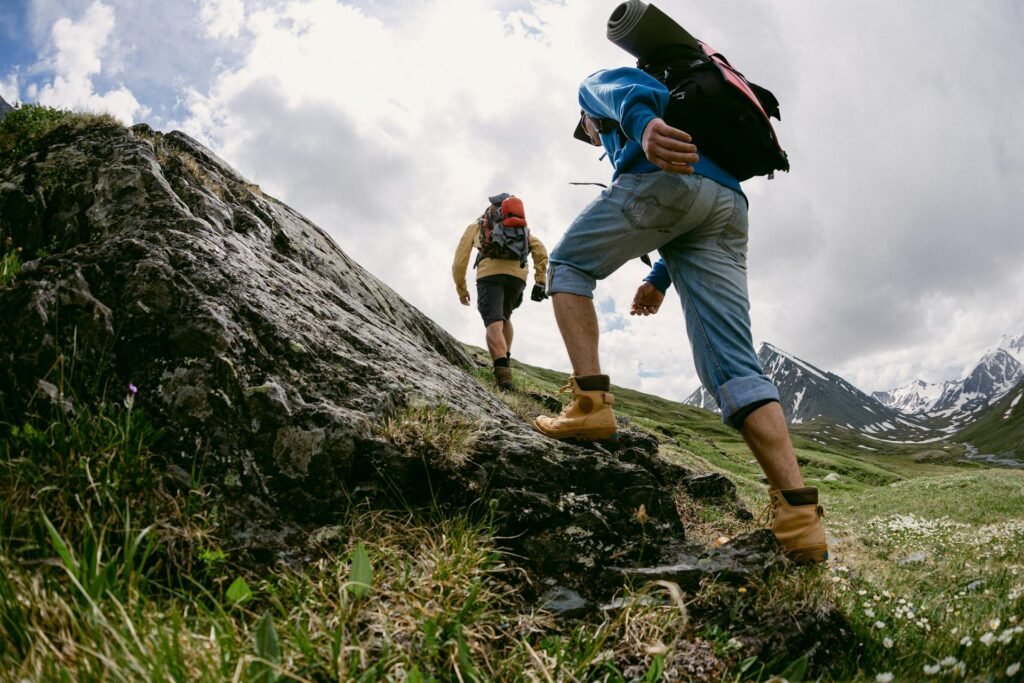
The Mallory Cave hike is considered an intermediate-level trek. The first 30 minutes are straightforward, with a mostly flat path, but the last hour becomes more challenging as you ascend a steep incline filled with rocks and boulders. The last part is the hardest, with enormous boulders and a narrow trail. You may need to use your hands for balance and support in some sections.
Essential Clothing for the Hike
Hiking to Mallory Cave in Boulder means walking on mixed terrain, so it’s essential to dress appropriately to protect your ankles, knees, and face from the rough path and sun exposure. Wearing sturdy hiking boots or shoes will help with grip and stability. Depending on the weather, you can choose between shorts or pants, and I love Kuhl hiking pants for their comfort and durability. An athletic top that wicks away sweat is also a great option, especially on warmer days.
Bring a light jacket like the Cotopaxi windbreaker to stay warm if you start your hike in the morning or evening. Layering with a fleece can keep you comfortable in the cold in winter or early spring. Don’t forget sunglasses and a hat, my favorite one is from Cotopaxi, to shield yourself from the sun. Dressing right makes the hike much more enjoyable!
Essentials to Pack for the Hike
Before starting the Mallory Cave hike, you should check out a blog post on the best hiking gear for beginners to ensure you’re well-prepared. Since the entire hike can take 2.5-4 hours, staying hydrated is key. Please bring a water bottle with a sleeve so you can carry it without using your hands. Protect yourself from the sun by applying sunscreen SPF, and don’t forget chapstick to keep your lips from getting dry.
A hip bag is great for keeping keys and other small things handy while you hike. If you like tracking your steps, a step counterwatch can help you see how far you’ve gone. Of course, bring your phone to take amazing photos along the way and capture the stunning views of the Flatirons. Packing wisely will make your hike much more enjoyable!
Helpful Tips for a Smooth Hike
It’s best to start early in the morning before it gets hot in the afternoon. Be sure to park at NCAR in the parking lot and bring plenty of water and SPF to protect yourself from the sun. As you hike, you’ll find many great photo opportunities, which only improve as you go higher. If you’re bringing a pet, remember that dogs are allowed in the area, but they must always be on a leash. If the hike feels too difficult, there are easier trails nearby, so you can change your mind and take a different route.
When sharing the trail, be respectful of other hikers. If someone approaches behind you quickly, step aside and let them pass. Uphill hikers always have the right-of-way, so stand aside for them. Always follow the “leave no trace” rule—pack out your trash, and don’t forget to carry out your dog’s poo bags. Lastly, keep in mind that Mallory Cave is closed from April 1 – October 1, so plan your visit accordingly.
Extend Your Hike with These Add-ons
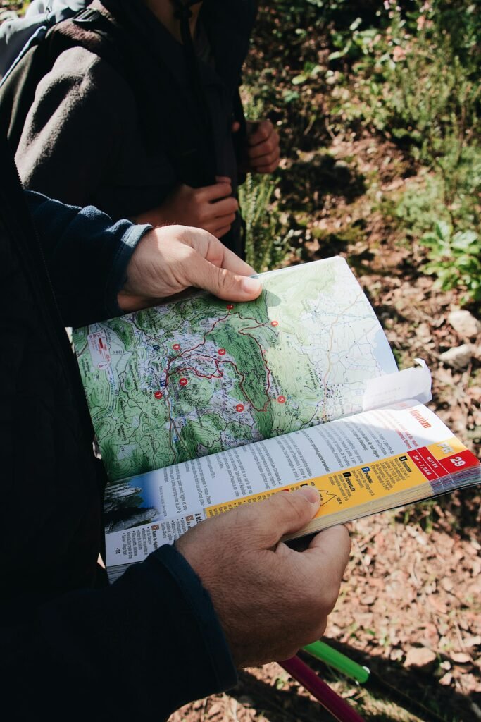
If you’re looking for a longer journey, there are TONS of hikes in the area that can be combined with the Mallory Cave route. Checking a map before starting can help you plan, as many trails are not fully listed. One excellent option is the Mesa Trail Loop, which runs perpendicular to the Mallory Cave trailhead and crosses through the valley. This loop also leads past NCAR and Table Mesa, allowing you to explore more of the region. You can take a detour onto the Skunk Canyon Trail for an extra adventure.
Another option is the Bear Canyon hike, which winds through the area and connects with the Bear Peak trail for those wanting an even more significant challenge. If you enjoy capturing nature, don’t forget to take a photo along the way—these trails offer stunning scenery at every turn. Whether you stick to the Mallory Cave hike or extend your path, there are plenty of options to make your experience unique.
Best Places to Eat & Drink After Your Hike
After finishing your hiking adventure, grab a meal or drink nearby. A great option is Southern Sun, a popular brewery and restaurant at the corner of Table Mesa and Broadway, slightly set back from the main street. They serve delicious beers and food but accept cash only—no credit cards. You can find it at 627 S Broadway Ste E, Boulder, CO 80305.
If you go early in the morning and want a hearty breakfast, stop at Southside Walnut Cafe. It’s a cozy spot that serves excellent breakfast dishes, perfect for refueling after an active day on the trails. You’ll find it at 673 S Broadway, Boulder, CO 80305. Whether you’re craving a cold drink or a satisfying meal, these spots are great choices to end your hike.
Best Places to Stay Near the Trail
If you’re visiting Boulder and want to stay close to nature, there are great options in the area that offer comfort and convenience. One excellent choice is Fairfield Inn & Suites, a hotel on South Boulder Road near Table Mesa and Highway 36. It’s right by the onramp, making it easy to get around. Guests enjoy free parking, a fitness center, and wifi. A continental breakfast is included, making it a great way to start your hiking day. The price for rooms ranges from $160-$220 in the summer and $130-$200 in the winter.
Homewood Suites by Hilton offers apartment-style accommodations with a swimming pool, kitchenette, and living room for a more home-like stay. There are even BBQ grills near the area for outdoor cooking. The price per night is around $250-$350/night, but during the winter, you can find rates as low as $150/night. This option is great if you prefer extra space and amenities after a long hike.
If you want a genuinely scenic experience, consider staying at the Colorado Chautauqua Cottages in Chautauqua Park, near the base of many hikes and a charming restaurant. You can enjoy a concert series in the park in the summer, making it a lively spot. The cottages come with a front porch; while breakfast is available, it comes with an additional charge. Expect to pay around $350/night in the warmer months, while winter rates range from $200-$250 per night.
Final Thoughts
The Mallory Cave hike is a must-try adventure for nature lovers and hiking enthusiasts. The trail offers breathtaking views of Boulder, the Flatirons, and the surrounding mountains. Whether you’re an experienced hiker or a beginner, this trail is worth exploring.
The hike starts near NCAR and takes you through rugged landscapes, tree-covered paths, and rocky terrain. The journey is challenging but rewarding, especially when you reach the top. If you love capturing nature, this hike provides incredible photo opportunities.
This trail also has a fascinating history, with Mallory Cave discovered in 1932. The area is protected, ensuring the safety of the bats that live there. If you’re visiting Boulder, don’t miss this hike; it’s an experience you won’t forget!
FAQs
1. Where is the best view of the Flatirons Boulder?
The best view of the Flatirons in Boulder is from the Mallory Cave hike or Chautauqua Park. Both spots offer stunning panoramas of the rock formations and surrounding landscapes.
2. What is the most leisurely hike up the Flatirons?
The Flatirons Vista Trail is the easiest hike up the Flatirons, offering a gentle path with scenic views. Another beginner-friendly option is the Chautauqua Trail, which is short but rewarding.
3. Why is Mallory Cave closed?
Mallory Cave is closed to protect Townsend’s big-eared bats from white-nose syndrome, a deadly disease. The cave entrance is blocked from April 1 to October 1 to prevent disturbances during their roosting season.
4. How do I get to Mallory Cave?
To get to Mallory Cave, start at the NCAR parking lot in Boulder and follow the trail signs. Hike along the Mesa Trail junction, pass the water tank, and continue uphill to the cave.
11 thoughts on “Mallory Cave Hike: Breathtaking Views of the Flatirons”
Лицензирование и сертификация — ключевой аспект ведения бизнеса в России, обеспечивающий защиту от непрофессионалов.
Обязательная сертификация требуется для подтверждения безопасности товаров.
Для 49 видов деятельности необходимо специальных разрешений.
https://ok.ru/group/70000034956977/topic/158831561783473
Нарушения правил ведут к приостановке деятельности.
Добровольная сертификация помогает усилить конкурентоспособность бизнеса.
Соблюдение норм — залог успешного развития компании.
Осознанное участие в азартных развлечениях — это принципы, направленный на предотвращение рисков, включая ограничение доступа несовершеннолетним .
Сервисы должны внедрять инструменты саморегуляции , такие как лимиты на депозиты , чтобы минимизировать зависимость .
Регулярная подготовка персонала помогает выявлять признаки зависимости , например, неожиданные изменения поведения .
https://sacramentolife.ru
Предоставляются ресурсы консультации экспертов, где обратиться за поддержкой при проблемах с контролем .
Следование нормам включает аудит операций для обеспечения прозрачности.
Ключевая цель — создать безопасную среду , где риск минимален с психологическим состоянием.
Дом Patek Philippe — это вершина часового искусства , где сочетаются точность и эстетика .
Основанная в 1839 году компания славится авторским контролем каждого изделия, требующей сотен часов .
Изобретения, включая автоматические калибры, сделали бренд как новатора в индустрии.
https://patek-philippe-shop.ru
Коллекции Grand Complications демонстрируют вечные календари и ручную гравировку , выделяя уникальность.
Текущие линейки сочетают инновационные материалы, сохраняя классический дизайн .
Это не просто часы — символ семейных традиций, передающий инженерную элегантность из поколения в поколение.
Доставка грузов из Китая в Россию осуществляется через железнодорожные маршруты , с таможенным оформлением на в портах назначения.
Импортные сборы составляют в диапазоне 15–20%, в зависимости от категории товаров — например, готовые изделия облагаются по максимальной ставке.
Для ускорения процесса используют серые каналы доставки , которые избегают бюрократических задержек, но связаны с повышенными рисками .
Оптовые рынки Китая
При официальном оформлении требуется предоставить сертификаты соответствия и декларации , особенно для сложных грузов .
Время транспортировки варьируются от нескольких дней до месяца, в зависимости от удалённости пункта назначения и эффективности таможни .
Стоимость услуг включает транспортные расходы, налоги и услуги экспедитора, что влияет на рентабельность поставок.
Back then, I believed medicine was straightforward. Doctors give you pills — you don’t question the process. It felt clean. Then cracks began to show.
At some point, I couldn’t focus. I blamed my job. Still, my body kept rejecting the idea. I read the label. None of the leaflets explained it clearly.
kamagra pills
It finally hit me: health isn’t passive. The reaction isn’t always immediate, but it’s real. Damage accumulates. Still we trust too easily.
Now I question more. But because no one knows my body better than I do. I take health personally now. It makes appointments awkward. This is survival, not stubbornness. The turning point, it would be keyword.
Хотите найти информацию о человеке ? Этот бот поможет детальный отчет мгновенно.
Воспользуйтесь продвинутые инструменты для анализа публичных записей в открытых источниках.
Выясните место работы или активность через систему мониторинга с верификацией результатов.
глаз бога поиск людей
Бот работает в рамках закона , обрабатывая открытые данные .
Закажите детализированную выжимку с геолокационными метками и списком связей.
Доверьтесь надежному помощнику для digital-расследований — точность гарантирована!
Rolex Submariner, представленная в 1953 году стала первыми водонепроницаемыми часами , выдерживающими глубину до 330 футов.
Модель имеет 60-минутную шкалу, Triplock-заводную головку, обеспечивающие безопасность даже в экстремальных условиях.
Дизайн включает хромалитовый циферблат , стальной корпус Oystersteel, подчеркивающие спортивный стиль.
rolex-submariner-shop.ru
Механизм с запасом хода до 3 суток сочетается с перманентной работой, что делает их идеальным выбором для активного образа жизни.
С момента запуска Submariner стал эталоном дайверских часов , оцениваемым как коллекционеры .
La montre connectée Garmin fēnix® Chronos est un modèle haut de gamme avec des finitions raffinées et fonctionnalités GPS intégrées .
Conçue pour les sportifs , elle allie robustesse et autonomie prolongée , idéale pour les entraînements intensifs grâce à ses outils de navigation .
Grâce à son autonomie allant jusqu’à 6 heures , cette montre s’impose comme une solution fiable , même lors de activités exigeantes.
garmin venu sq
Les outils de suivi incluent la surveillance du sommeil , accompagnées de notifications intelligentes , pour les utilisateurs exigeants.
Intuitive à utiliser, elle s’intègre à votre quotidien , avec une interface tactile réactive et synchronisation sans fil.
La gamme MARQ® de Garmin est un modèle haut de gamme avec un design élégant et fonctionnalités GPS intégrées .
Conçue pour les sportifs , elle allie robustesse et autonomie prolongée , idéale pour les aventures en extérieur grâce à ses outils de navigation .
Avec une batterie allant jusqu’à 6 heures , cette montre reste opérationnelle dans des conditions extrêmes, même lors de sessions prolongées .
https://garmin-boutique.com/forerunner/forerunner-955-noire.aspx“>garmin 955
Les fonctions de santé incluent la surveillance du sommeil , accompagnées de notifications intelligentes , pour les utilisateurs exigeants.
Intuitive à utiliser, elle s’adapte à vos objectifs, avec un écran AMOLED lumineux et compatibilité avec les apps mobiles .
This platform aggregates breaking updates on designer collections and emerging styles, sourced from权威 platforms like Vogue and WWD.
From chunky accessories to sustainable fabrics, discover insights aligned with fashion week calendars and trade show highlights.
Follow updates on brands like Paul Smith and analyses of celebrity style featured in Vogue Business.
Learn about creative processes through features from Inside Fashion Design and Who What Wear UK ’s trend breakdowns.
Whether you seek streetwear trends or shopping recommendations, this site curates content for enthusiasts alike.
https://showbiz.luxepodium.com/
Наш ресурс публикует актуальные инфосообщения в одном месте.
Здесь представлены факты и мнения, науке и многом другом.
Новостная лента обновляется регулярно, что позволяет держать руку на пульсе.
Удобная структура делает использование комфортным.
https://ryazansport.ru
Каждая статья оформлены качественно.
Мы стремимся к достоверности.
Следите за обновлениями, чтобы быть на волне новостей.